Partners: Experience Architecture Program and Museum Studies Program
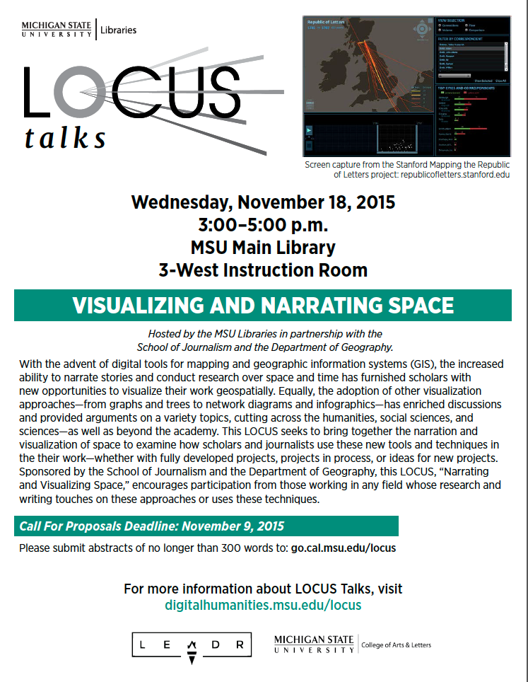
Theme: Access in a Digital Environment
Date: 2/24/2016
Time: 3:00-5:00
Location: Libraries, REAL Classroom, 3 West
While more websites and digital experiences are created, we must ask questions about access. In order to foster an interdisciplinary conversation on this topic we are seeking proposals up to 300 words for 7-10 minute presentations that engage with one or more of the following issues:
- Who are the multiple audiences for websites, online collections, or mobile apps?
- How do the affordances of various digital environments impact the notion of access?
- What assumptions are made about user ability to interact with these digital environments?
- What design decisions are made to encourage successful navigation in these environments?
- What constitutes successful navigation of a digital environment?
- How can different modes of engagement facilitate use for diverse communities?
We are especially receptive to hearing about works in progress relating to research, teaching, or any other type of work that wrestles with the challenges of access in the digital environment. Proposals from students (undergraduate and graduate), faculty, and staff are all encouraged equally.
Call for Proposals deadline: February 15, 2016
Please submit abstracts no longer than 300 words to: go.cal.msu.edu/locus
Please register to attend at: classes.lib.msu.edu/view_class.php?class_id=159
Aurality, the Sonic Self, and the Mobile Device: Pathways for Interaction Design
Ben Lauren, Brooke Chambers
Interaction design as a field often emphasizes the visual over the aural (Follet, 2007). Lord (2004) explains the rationale: “audio feedback is an unreliable communicator of complex information (at least of anything other than panic), [and] it is often relegated to a secondary or illustrative role” (n.p.). We’ve all been interrupted by the sounds emitted by someone’s mobile device at a meeting or public place. In the book Acoustic Territories, Brandon Labelle (2010) explains, “sound opens up a field of interaction” (p. xvii) and cites Connor (1997) as he illustrates the concept of “the sonic self” as a sort of “membrane” or “channel” that sound passes through (p. xx). Labelle (2010) also suggests the sonic self is made up of cultural, historical, technological, and embodied situations and conditions that influence listening and how people experience and interact with sound. It is in this way, filtered through the sonic self, disagreeable sounds can elicit frustration or annoyance. Based on our own experiences with sound and mobile devices we are asking a central question: since interaction designers diminish the usefulness of audio feedback, what aural experiences or limitations are (perhaps unintentionally) programmed into people’s experiences with mobile devices? This presentation reflects on the above question by discussing the concept of the sonic self as a sort of heuristic for designing aural experiences with mobile phones. We discuss and seek feedback on our methods for answering this question, and seek feedback about our project.
Sara Bijani
I am a fellow in the Cultural Heritage Informatics Initiative here at
MSU, currently building an Omeka/OHMS gallery showcasing the Finally
Got the News related materials here in Special Collections. I would like
to briefly discuss the (significant) copyright and access conflicts
I’ve encountered in this project, and to encourage a stronger defense of
fair use digital educational access on our campus. I know I am not
alone in expressing these concerns, but the problems of access are
especially relevant and concerning for the particular project I’ll
discuss. The small corpus of work I’m interested in was collected in the
late 1970s by a complicated group of Marxists, anarchists, and their
various sympathizers and affiliates. The raw audio footage collected by
these people offers glimpses of their interjections in the logics of
late capitalism, as they rallied and lectured and marched against the
racial violence of industrial labor in the manufacturing core of the
nation. Locking away the raw material of this revolutionary effort under
obscure and imprecise copyright, rendering it unheard and unknown, does
that material violence at its very center, as well as violates the core
impetus of its creation. We need to find a better way.
The Bot Wars: Russian Censorship and Citizen Subversion of Public ‘Nonhuman’ Discourse
Jack Hennes
Following the 2011 Russian legislative election results, activists on
Twitter used the #триумфальная (Triumfalnaya) hashtag to express their
disgust with what they believed to be a flawed election process. Within
hours, Triumfalnaya become one of the most widely used hashtags on
Twitter. In response, a flood of pro-Kremlin tweets was sent by bot
accounts to the Triumfalnaya hashtag, effectively drowning out the
voices of protesters. This is one of many instances of the Russian
government’s use of twitter bots to control civic discourse and
resistance, especially when citizens attempt to mobilize and subvert the
state’s use and misuse of power.
In this presentation, I survey the use of Russian bots created to
censor and control users with Russian ISP addresses. I begin by briefly
describing Roskomnador, the federal service for media supervision in
Russia and the passing of the Russian Internet Restriction Bill of 2012.
I’ll then highlight three examples of state control and “netizen”
subversion from May through July, 2014. In the first, Roskomnador
demanded that all social media accounts with 3,000 daily readers must
register with the Russian government and reveal their true identities.
Following in June 2014, Roskomnador blocked all 485 million pages
generated by Archive.org’s legion of Wayback Machine bots. Lastly in
July 2014, a twitter bot monitoring the Russian government’s anonymous
edits of Wikipedia pages revealed a shocking change of language pointing
to the persons responsible for shooting down Malaysia Airlines Flight
17 in the Ukraine.
Based on these cases, I will conclude by highlighting how social
media analysis can help researchers distinguish between human and
nonhuman communication networks. As state control of public discourse
with nonhuman agents seems to be at its peak, understanding the
formation and distribution of bot networks is vital. However, it’s
equally vital to consider how bots are being created to subvert control
of the state in inspiring ways. I conclude by suggesting how nonhuman
agents and the control of online discourse may well be the future of
activism in the 21st century.
User Experience and Power
Heather Noel Turner
I would like to show a 7-10 minute presentation of my current inquiry
related to UX/XA, design, and issues of power. I hope to address argue
for the importance of acknowledging cultural contexts, politics of
interfaces, and consequences of user resistance.
Viable VR: BOYD Immersive Multimedia
Eric Martin, Tommy Truong
Immersive multimedia is content that allows participants to engage in
a more tangible and interactive context through placing them within
environments from either the real world or computer-replicated
simulations. While originally developed to immerse users within games,
this technology has recently transitioned outside of the gaming industry
into fields such as education, business and healthcare. We believe that
with the right direction, immersive multimedia can further benefit
existing pedagogy if it can become more affordable and widely available.
The current use of immersive multimedia within academia have been
relatively basic, but continued practice and support for these new
methods could lead to far greater content being developed to help the
academic community prosper. One example of this application is the
Innovations Team at Michigan State University’s College of Arts &
Letters, who developed a method for organizations such as the Detroit
Institute of Arts to quickly model museums in 3-dimensions, making
explorable exhibits for visitors to see first-hand and promote
interactions on a deeper level than the traditional exhibit. Dr. Jon
Frey, a professor with Michigan State University’s Art and Art History
department, is currently creating methods to use immersive, embodied
experiences to aid in the delivery of historical art content in the
classroom.
Another aspect of current uses of immersive multimedia is its
expense. With price tags of the Oculus Rift and Hololens ranging from
$500 to $3000, these devices are very expensive and are unfortunately
not always viable for a classroom or personal environment. We hope to
adapt this technology to be much more accessible and affordable by
utilizing existing technologies that are more accessible. Through
tapping into the expansive market of smartphones, we can create much
more affordable methods of teaching and experiencing immersive
multimedia.
Accessible Learning Experiences for Students with Disabilities
Phillip J. Deaton, Jessica Schein, and Anuj Shah
Student experiences at universities are created in large part in
digital environments. What kinds of challenges do students with
disabilities face and how do web, course, and content developers build
digital environments that are inclusive and engaging? This presentation
will run through the types of digital environments that students use,
the types of barriers the students with disabilities in higher ed face,
and the design strategies and questions to use when planning curricula,
courses, websites, and content that will be accessible.
Concepts, Workflows, and Lessons Learned in the History Department from Providing Transcriptions and Accessible Online Courses
Rachael Firehammer, Sam Jaksa, and DeLacey Yancey
With more and more course being placed online, it has become
essential for departments to ensure that these online courses are made
accessible to students with disabilities. One of the major components of
this is standardizing online lectures so that they are closed
captioned. The Americans with Disabilities Act (ADA) requires that this
must be completed for all online lectures within the next five years.
The History Department has been working on this process for over a year
now, while also focusing on other accessibility components, such as
editing websites so students with screen readers are able to navigate
the history department and course websites. While automatic
transcription software continues to improve, the resulting captions
always have errors – sometimes so many that correcting the results can
take even longer than manual transcription. The main process of
transcribing and captioning for the Department of History involves the
use of Kaltura Mediaspace and other software such as Express Scribe and a
text editor. The task of transcribing lectures involves uploading
videos onto the MSU Mediaspace and then editing the text after the
program has automatically transcribed the lecture. After editing the
transcription, within a text editor, the video and the captions are
complete. This transcription and captioning process is very important to
make sure that online course videos are accessible to everyone who
needs to watch these lectures for their class.
Connection over Content: Building a Digital Strategy at the MSU Museum
Max Evjen
Museums are dynamic, educational, and engaging. However, the
traditional audience demographic for museums continues to be old and
white. This is a troubling fact considering the increasing minority
population in the United States, and it’s more troubling for the MSU
Museum since it seeks to engage the traditional target audiences at
museums (K-12, adults and families) but, as a University museum, it also
seeks to engage a diverse student population.
In order to be a more social, connected, inclusive, and
visitor-centered organization, the Museum is formulating a digital
strategy using the Digital Engagement Framework, a free tool developed
by MuseumNext Practice. According to the MuseumNext Practice website,
“The Digital Engagement Framework helps you identify the value creation
opportunities of digital engagement for your organisation and develop
the strategies, processes and technologies to structurally engage your
audience to maximize your co-created value.” The Framework has been used
in a variety of settings including museums, festivals, heritage sites,
performing arts organizations, by individual artists, and for specific
exhibitions.
The development of a strategy using the Framework requires the
participation of many individuals who are all increasingly busy and
under-resourced, and who are from all different departments in an
organization. Max Evjen, Exhibitions Technology Specialist at the MSU
Museum will describe the successes and challenges in developing the
Digital Engagement Framework, and will share how the Framework can be
used in other organizations.
Participatory Museums: The User Experience of Creative Agents
Erin Campbell
User experience (UX) is an emerging field, and many businesses and
institutions are coming to the realization that, although the quality of
a product is important, the user’s experience with it often influences a
product’s success. Some organizations, such as museums, still wrestle
with how to best implement UX methods to learn about customer
experiences. Too often people view museums as places to visit once and
never return to. Cultural artifacts hang on walls next to “Do Not Touch”
signs and museums remain bound by traditional ways of interacting and
participating in art. But what if curators took down the “Do Not Touch”
signs and encouraged visitors to participate as part of the experience?
This research project will explain the participatory work I am doing
with the Eli and Edythe Broad Art Museum at Michigan State University.
The museum has encountered a unique challenge collecting information on
visitors given that people are not required to stop at the front desk to
pay for admission or interact with museum staff. Thus, most visitors
participate and leave while remaining anonymous.
To help solve this problem, I have designed a project aimed at
discovering the experience of visitors to better understand how the
museum could encourage different kinds of participation. Researching
visitors’ experiences could provide an appropriate time and place for
collecting information. Visitors would no longer come and go
anonymously.
For my presentation(s) at LOCUS, I will explain the results of this
research, noting how the case can inform future work with museums. I
will also explain how what I learned connects to other important work in
UX, like service design and participatory design. Finally, I will
address the promise of this work as someone interested in doing UX work
in museums as a future career goal.


